
|
|
|
I am indebted for the images and pdf extracts on this page to Tom Moss. Tom is a great enthusiast for the history of the borders region and is an expert on the history of the area. Visit his site here: http://www.reivershistory.co.uk/
|
Wikipedia Extract The Battle of Degsastan was fought c. 603 between king Æthelfrith of Bernicia and the Gaels under Áedán mac Gabráin, king ofDál Riada. Æthelfrith carried the day, winning a decisive victory, although his brother Theodbald was killed. We know almost nothing else about the battle, not even where "Degsastan" was supposed to be. Some suspect it was Dawstane in Liddesdale. According to Bede's account in his Historia ecclesiastica gentis Anglorum (Book I, chapter 34), Æthelfrith had won many victories against the Britons and was expanding his power and territory, and this concerned Áedán, who led "an immense and mighty army" against Æthelfrith. Although Æthelfrith had the smaller army, Bede reports that almost all of Áedán's army was slain, and Áedán himself fled. After this defeat, according to Bede, the Irish kings in Britain would not make war against the English again, right up to Bede's own time (130 years later). Áedán's army included the Bernician exile Hering, son of the former Bernician king Hussa; his participation is mentioned by theAnglo-Saxon Chronicle (manuscript E, year 603), and may indicate dynastic rivalry among the Bernicians. Áedán's army also included the Cenél nEógain prince Máel Umai mac Báetáin, who is said by Irish sources to have slain Eanfrith, brother of Æthelfrith. Áedán survived as King of Dál Riata until 608 when he was succeeded by his youngest son Eochaid Buide. Æthelfrith died in battle in 616.
Useful discussion thread on: http://senchus.wordpress.com/2008/11/15/the-battle-of-degsastan/#comments Local Archeological Paper on the battle from 1903 Another paper discussing graves on the battlefield
Video clip from the borders region:
|
|
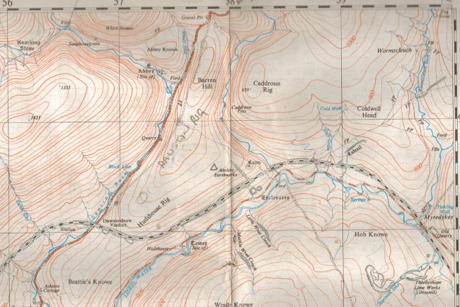
Below: Victorian Era MapInteresting how the Catrail is marked here but called "old road" on the other modern map. |
|
|
|
|


|
 |
Want to know where to buy my books? |
|
|
Purchase viaAmazon |
| The Kindle Edition: |
|
Paperback:
|
|
E-book version available via Smashwords |
only $1.99 (about £1.35p) |
Audio Version availablevia Podiobooks
|
Become a Fan of the book on Facebook
|
Follow the author on Twitter
|